Rural Fire Service:
Fire Trail Mapping
Cover page
Map sheet
Map sheet
Project Name
Rural Fire Service - Fire Trail Mapping
the aim
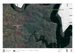
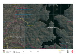
The Rural Fire Service (RFS) required cartographic quality maps of fire trails to be used by its outdoor staff and volunteers. The maps needed to:
- Be durable
- Be easy to use
- Be of high cartographic quality
- Display fire trail location, classification and capacity
- Display aerial photography and contours
the solution
A3 laminated booklets were produced using:- Microsoft .NET
- Adobe InDesign
- Digital printing
The booklets include:
- A sheet key
- An index of all fire trails with map references
Fire
trail data supplied by the RFS was themed and labelled. The data was then split
into map sheets to ensure good scale and coverage. Cartographic maps where then
created and prepared for printing by a digital printing service.
Tags
more details
For more details please use our 'Contact us' page or email us at info@spatialintelligence.com.au